Two plans, one map
Free does the everyday. Premium fits your van.
Radar Free does the everyday brilliantly and costs nothing. Radar Premium is for full-timers and anyone who wants the richer map and routing that understands the size of their vehicle.
Finding places works anywhere in the world. Route planning covers Great Britain today, on both plans, and more countries follow as we build their roads in.
Open Radar Free →Compare plans
| Feature | Radar Free | Radar Premium |
|---|
| The map | | |
| Map and search built on open map data | ✓ | ✓ |
| Satellite and street view | | ✓ |
| Places the open data misses | | ✓ |
| Offline maps on mobile | | Coming soon |
| Finding things | | |
| All 45 categories and hazard layers | ✓ | ✓ |
| Clean air and charging zones, priced for your vehicle class (London, Bath, Bristol and France) | ✓ | ✓ |
| Roadworks, closures and road events on the map (France and the Netherlands) | ✓ | ✓ |
| Live government fuel prices, in the countries that publish them | ✓ | ✓ |
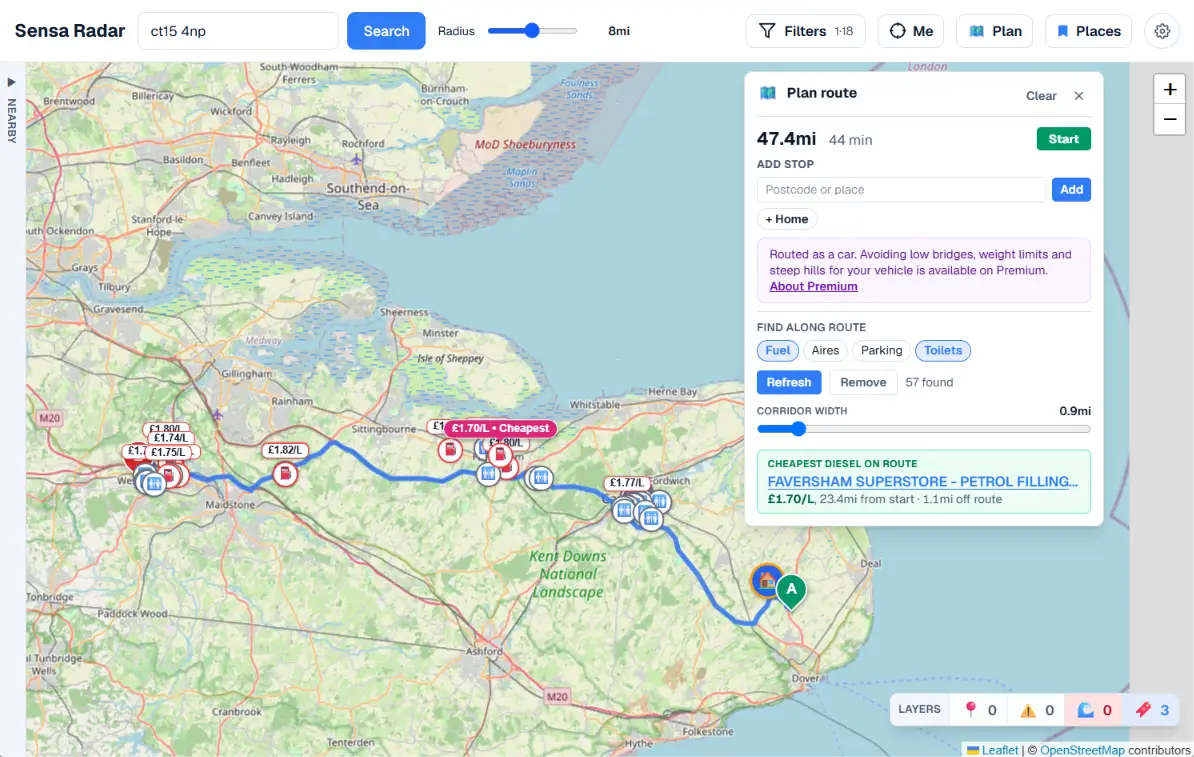
| Amenity search along a planned route (Great Britain only) | ✓ | ✓ |
| Basic A-to-B route planning (Great Britain only) | ✓ | ✓ |
| Built for your van | | |
| Hazard warnings matched to your height, width and weight (Great Britain and Ireland) | | ✓ |
| Vehicle-aware routing, allowing for your size and weight (Great Britain only) | | ✓ |
| Everyday | | |
| Web, iOS, Android and Home Assistant | ✓ | ✓ |
| Optional account with sync across devices | ✓ | ✓ |
| Saved places, including home and work | 100 | 1,000 |
| Free trial | Not needed, it’s free | 7 days |
| Price | Free | £3.95/month or £24.95/year |
Trying Premium
Premium starts with a 7-day free trial. We take your card details when you start it, and we do not charge you during the trial. Here is the whole of it:
- Nothing is taken on day one. Your first payment is 7 days later, at £3.95/month or £24.95/year depending on which you picked.
- We email you 2 days before that happens, so the charge is never a surprise.
- Cancel during the trial and you are not charged at all. You keep Premium until the trial ends either way, so cancelling early costs you nothing.
- Cancelling takes one click in MySensa, and you can do it at any time afterwards too.
- One free trial per Sensa account.
The full terms are in the Radar terms of use.
Three things the comparison table cannot say for itself:
- Route planning covers Great Britain only at the moment. That applies to basic A-to-B routing, to vehicle-aware routing and to amenity search along a route, on both plans. Finding places, the map and every category work anywhere in the world.
- Offline maps on mobile are not available yet. They are in development and will be part of Radar Premium when they arrive. Everything else marked Premium in the table works today.
- Live fuel prices come from each country’s own government feed, so they cover the countries that publish one: Great Britain, France and Spain, each refreshed every 30 minutes. In France and Spain that includes LPG. Prices are shown in the money of the country you are in, and you can optionally convert them into your own currency for a rough comparison. Elsewhere Sensa Radar still shows fuel stations, without a live price. The coverage table below has the country-by-country detail.
Open Radar Free in your browser now, or start your 7-day Premium trial.
Every Nomad system includes Radar Premium, through the Sensa Nomad Support Plan, and the first year of that plan is included in the price of the system. How many licences depends on the tier: one on Base, two on Pro, two on Vision and two on AI. Inside Nomad, Radar draws position from the van’s own router and puts hazard warnings on the cab screen while you drive. Explore Nomad.
Radar in detail
This is the deep end: everything Radar can find, where the data comes from, and exactly what the vehicle-aware features do. For the genuinely in-depth version, every screen and setting explained, head to the Radar documentation.
What it does
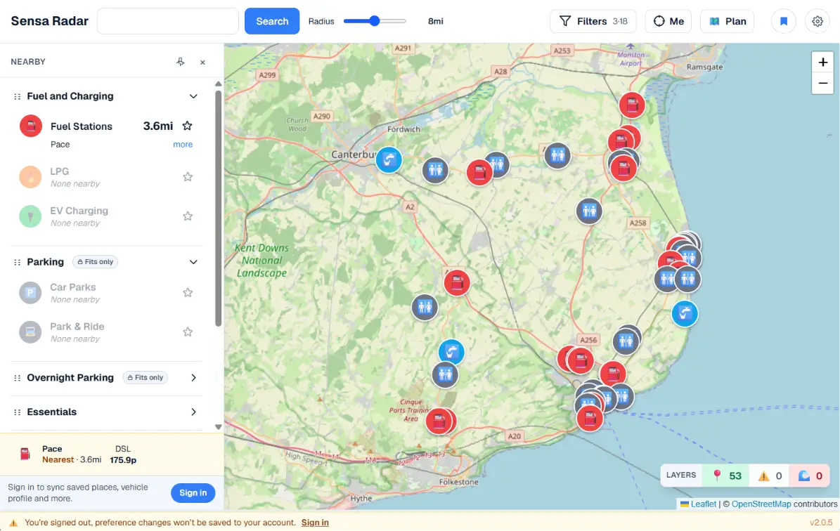
- Nearest view. One result per category, grouped and reorderable. Star the ones that matter to pin them to the top.
- Drill down. Tap any category to see every result in your radius, filterable by data source.
- Upcoming hazards. When you’re moving, Radar watches a cone ahead of you and warns you about restrictions in your path before you reach them.
- Curated national data. In Britain, toilets, fuel prices, EV chargers, ATMs, NHS pharmacies and dentists, MOT centres, libraries, bathing waters, parks and more come from authoritative open sources, not scraped from a single map provider. London’s emission and charging zones come from the GLA and TfL, and the Bath and Bristol Clean Air Zones from the West of England Combined Authority. France has live government fuel prices, the national register of clean air zones, the national register of aires de camping-car and live roadworks and closures on its national roads; Spain has live government fuel prices; the Netherlands has national roadworks and closures; Belgium has its national register of certified food businesses. See where Radar works for the country-by-country detail.
- Clean air and charging zones. France’s Crit’Air zones are shaded on the map from the government’s own register, with the minimum sticker for each class of vehicle, the hours it applies and a link to the city’s rules. London’s Ultra Low Emission Zone, Low Emission Zone and Congestion Charge sit on the same layer, from the GLA’s and TfL’s own boundaries. The van and motorhome answer is listed first, because it is routinely different from the one for cars, and in London that difference is £12.50 against up to £300 a day: a motorhome over 3.5 tonnes falls outside the ULEZ and inside the LEZ, and the two share a boundary. England’s Clean Air Zones in Bath and Bristol sit on the same layer, and they are a different trap again: what you pay is set by the vehicle category on your V5C rather than by size, so the same motorhome can be free in Bath and £9 a day in Bristol. Only the boundaries are published as open data, so the charges and emissions standards are maintained by hand and every zone shows the date a person last checked them. Zones that have not started yet are marked as such rather than shown as live restrictions. Free on both plans.
- Roadworks and road events. Roadworks, closures, accidents and obstructions on their own map layer in France and the Netherlands, colour-coded so work under way, a closed road and something planned but not started are told apart at a glance. Planned work is shown up to a month ahead, which is the difference between finding out about a shut road while you can still change the plan and finding out on the day. Where the road authority publishes the shape of the affected stretch, Radar draws it. Free on both plans.
- The community map. Add a place, add a photo, or say whether you would go back, anywhere in the world. Every submission is reviewed before it goes live, aggregates are always over the last twelve months rather than all time, and one tap confirms a place is still there. There are no star ratings. Free on both plans, and it needs a free Sensa account.
- Hazard layers. Low bridges, weight limits, narrow lanes and active flood warnings, each rendered as its own map layer. The restriction data covers Great Britain and Ireland today, from National Highways and from OpenStreetMap’s surveyed limits, and flood warnings cover England. We would rather tell you where we have looked than leave an empty layer reading as an all-clear. Free on both plans, and you do not need an account to see them.
- Hazards matched to your vehicle. Set your height, width and weight once and Radar flags only the hazards that actually block you, instead of every restriction on the map. (Premium only, Great Britain and Ireland)
- Vehicle-aware routing. Plan a route that already avoids the hazards your van can’t clear, no separate truck-routing subscription required. (Premium only, Great Britain only)
Find
- Search by place name, postcode, ///what3words address or your own position, with an adjustable radius (0.5 mi → 60 mi, fine at the low end)
- 45 categories across 10 groups: Essentials, Fuel & Charging, Food & Drink, Health, Vehicle Services, Parking, Overnight Parking, Leisure, Overland, Community Reports
- Pan the map somewhere else and a Search this area pill offers to run the search there. It appears once you have moved a fair way from the last search and stays out of the way while the map is following you
- Filter results by category and by data source from one panel, with a search box for finding a category by name. Set everything up, then apply it once, so a handful of changes is a single search rather than one per tick
- Nearest-first ranking across every source
Categories and what each shows
- Essentials: toilets, launderettes, post offices, Amazon lockers, ATMs, drinking-water refills
- Fuel & Charging: petrol/diesel stations with live prices, LPG/Autogas, EV charging with connector types
- Food & Drink: supermarkets, restaurants, cafes, pubs with FSA hygiene ratings
- Health: pharmacies, hospitals, dentists, vets
- Vehicle Services: mechanics, MOT stations, tyre shops
- Parking: car parks, Park & Ride, with fee, max stay, capacity, and vehicle-size limits where OSM has them
- Overnight Parking: motorhome aires, laybys, private hosts who take guests by permission
- Leisure: campsites, gyms, swimming pools, parks, libraries, designated bathing waters with EA water quality
- Overland: border crossings, customs and immigration, checkpoints, consulates and embassies, vehicle insurance, vehicle shipping, vehicle storage, black-water dump stations, showers, oversized-vehicle parking
- Community Reports: road reports, warnings, and spots where overnight stopping is prohibited, all added by other owners
Where Radar works
Sensa Radar searches anywhere in the world. What changes country by country is how much of the map we hold ourselves and how many national sources sit on top of it.
- Live now: Andorra, Austria, Belgium, Denmark, France, Germany, Great Britain, Luxembourg, Netherlands, Northern Ireland, Norway, Portugal, Republic of Ireland, Spain, Sweden and Switzerland. Their map data is loaded into Radar’s own database, so the nearest list comes back in a moment. That is the width of western Europe and up into Scandinavia, and more follow as we build them in.
- Anywhere else. Radar queries a public map service live instead. You still get places, it simply takes longer to answer, and the national sources in the table below apply only to the countries that have them.
Route planning is a separate question from finding places. Both the basic A-to-B route and the vehicle-aware version run on road data we build in ourselves, and that covers Great Britain today, so Radar cannot plan a drive outside Britain yet whichever plan you are on. Basic routing is free; the vehicle-aware layer that allows for your height, width and weight is Premium.
What you get, country by country
Sensa Radar’s coverage by country, as of August 2026. Every country gets the base map and all 45 categories; what varies is whether we hold the map data ourselves and how many national sources sit on top of it.
| Country | Places on the map | Fuel prices | Other national sources | Route planning |
|---|
| Andorra | Held by us, instant | None yet | None yet | Not yet |
| Austria | Held by us, instant | None yet | None yet | Not yet |
| Belgium | Held by us, instant | None yet | Certified food businesses (AFSCA/FAVV Smiley list) | Not yet |
| Denmark | Held by us, instant | None yet | None yet | Not yet |
| France | Held by us, instant | Every 30 minutes, French Gov | Clean air zones (ZFE), national aires register, roadworks and road events | Not yet |
| Germany | Held by us, instant | None yet | None yet | Not yet |
| Great Britain | Held by us, instant | Every 30 minutes, UK Gov | 15 more national sources, including London's ULEZ, LEZ and Congestion Charge and the Bath and Bristol Clean Air Zones | Yes, vehicle-aware on Premium |
| Luxembourg | Held by us, instant | None yet | None yet | Not yet |
| Netherlands | Held by us, instant | None yet | Roadworks and road events | Not yet |
| Northern Ireland | Held by us, instant | None yet | None yet | Not yet |
| Norway | Held by us, instant | None yet | None yet | Not yet |
| Portugal | Held by us, instant | None yet | None yet | Not yet |
| Republic of Ireland | Held by us, instant | None yet | None yet | Not yet |
| Spain | Held by us, instant | Every 30 minutes, Spanish Gov | None yet | Not yet |
| Sweden | Held by us, instant | None yet | None yet | Not yet |
| Switzerland | Held by us, instant | None yet | None yet | Not yet |
| Everywhere else | Fetched live, slower | None | None | Not yet |
“None yet” means we have no national source for that country so far, not that Radar shows nothing there: OpenStreetMap covers most categories everywhere, and a national source is what makes a category complete and current rather than best-effort.
Where the data comes from
Sensa Radar is fed by 30 data sources, and they fall into three kinds.
- Government and official feeds carry the things that have to be right and current: live fuel prices, NHS pharmacies and dentists, MOT centres, flood warnings and road restrictions. These are the reason a Radar result is worth more than a pin dropped on a generic map.
- The community adds and confirms the places no register holds, the layby that works and the tap that runs. Owners can add photos and say whether they would go back, and every place carries the date it was last confirmed, so a listing that has gone quiet says so instead of looking current. There are no star ratings.
- Commercial data fills the gaps and provides the richer map with satellite and street view on Radar Premium.
Underneath all three sits OpenStreetMap, the backbone across every category, held in our own database for the countries above and fetched live everywhere else.
Most official sources are national by nature, which is why coverage grows a country at a time rather than all at once. Great Britain has the deepest stack today, France has its government fuel feed, its clean air zone register, its national register of aires and its national roadworks feed, Spain has its government fuel feed, the Netherlands has its national roadworks feed, Belgium has its certified food business register, and each new country brings its own.
Every source named individually, with what it covers and how often it refreshes, is in the Radar documentation.
Vehicle-aware
- Save your vehicle profile once and it is reused everywhere: height, width, length, weight, and the steepest gradient you are willing to take
- Steep hills. Set a maximum gradient and the route planner detours around any climb steeper than that, which matters as much as a low bridge if you are heavy or underpowered. There is an override for the times you would rather just take the hill
- Map pins for parking and overnight stops flag whether you fit
- Live hazard overlay: low bridges, weight/width/length restrictions, from OSM + National Highways (Great Britain and Ireland)
- Route planner: honours your profile AND detours around Sensa Radar’s ingested hazards, not just OSM tags. Basic A-to-B routing is free and needs no account; the vehicle profile is what Premium adds
- Route view shows the hazards and the steep climbs it avoided, so you understand the detour
- Services-along-route: see fuel, food, toilets, etc scoped to your planned route
Live
- The map’s own “Me” button has three states: Off → Tracking → Following. “Following” auto-recentres the map as you drive; drag the map to drop back to Tracking. This is the map keeping up with you on screen, and is a separate thing from the Tracking feature that records your van’s journeys into MySensa
- Heading arrow from compass, GPS course, or motion-derived
- Upcoming-hazards banner based on your heading
- EA flood warnings rendered live on the map (amber / red / severe)
- NASA active fire detections across Europe on the hazards layer, updated hourly, free on both plans
Accounts and privacy
Radar can be used without a Sensa account. Without one, your preferences live in your browser. With one, they sync across web and mobile, and an account is what lets you save places, submit to the community map and take out Premium. Your searches are recorded against your account with the location rounded to about a kilometre, enough to show us which areas people search in and not enough to identify an address. Turn on Tracking and your van’s journeys are recorded into your MySensa account; it stays off until you switch it on. The Radar section of our privacy policy sets out all of it, including how long we keep each kind of record.